Partners
A Decade of Partnership

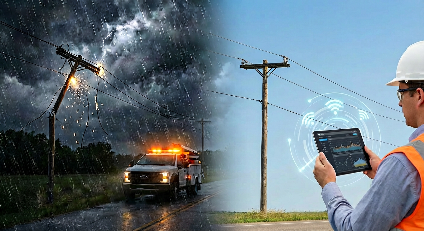
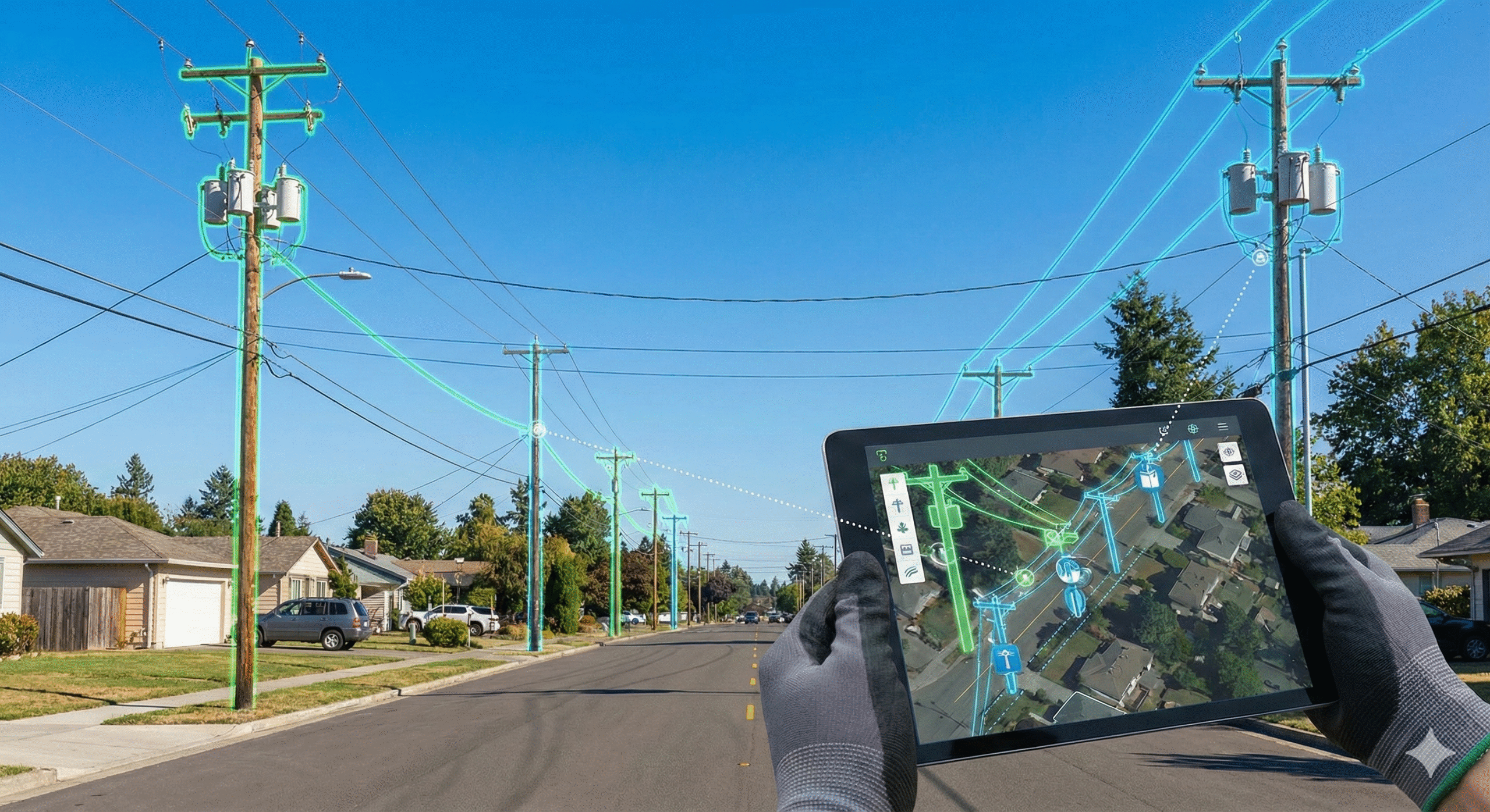
Modernize Your Operations with a Premier Google Partner
From building Gemini AI agents to securing cloud infrastructure, we leverage 180+ certifications to help you implement the right technology. We drive measurable, location-powered results through automation and analytics.

Google Cloud
Modernize applications, infrastructure, and data on a secure and resilient cloud foundation.
Gemini Enterprise
Build and manage AI agents to unlock enterprise potential and automate complex workflows.

Google Cloud Security
Protect, detect, and respond to threats at scale while prioritizing remediation and ongoing compliance.

Google Maps
Power location-based applications using rich data and modern mapping experiences to optimize fleet and logistics.
Vertex AI
Google's managed platform for building, deploying, and scaling machine learning models.

Google Workspace

Satellite Imagery Providers and Partners
Capella
24/7 Monitoring
Rapid, High Resolution & Accuracy
Surface Mapping
Imagery Enhancements
Change Detection with Scaled Coverage

“Woolpert helped us simplify how we work with Google Maps and Cloud. Their support made pricing more predictable and scaling much easier as our platform grew.”
“Woolpert is doing things that few, if anyone else, can do. Their expertise stands out, especially for the complex routing problems we’re solving.”

“Woolpert has been a great partner in helping us explore and adopt new Google Cloud capabilities. They bring us innovative ideas and early access to tools that add real value to our platform.”
“I had a ton of questions during implementation, and Woolpert always got me the answers right away. The documentation was strong, and the whole process was smooth from the start.”

“Woolpert’s report was super comprehensive. It flagged things we wouldn’t have found ourselves and gave us a clear roadmap for improving our stack.”

“Our partnership with Woolpert and Google Maps Platform has transformed the way our users find and secure monthly housing, making searches faster, easier, and more reliable.”
“Our partnership with Woolpert and Google is enabling us to apply the latest AI technology, putting Minisoft at the forefront of innovation in the legal market.”
“Woolpert’s team made everything easier. Even basic questions were answered quickly, without the hassle of going through a generic support line. Their help during the API migration saved time and gave us confidence that everything was set up correctly.”
“Woolpert helped us cut through the noise and figure out what would actually work. Their guidance made the process faster and easier, and they’ve continued to be a solid partner.”
“Woolpert made our transition to Google Maps seamless. Their team helped us optimize our usage and make sure everything worked exactly how we needed it to. It’s been a strong partnership.”
“When we needed to move to a paid API, Google connected us with Woolpert, and the transition was seamless. They’ve been a helpful, responsive partner throughout the process.”
“We met with Woolpert early on and were quickly impressed by their expertise. Their internal pipelines analyze petabytes of geospatial data, just like ours, so it was a natural fit to talk shop with other engineers solving similar problems.”
“The communication was clear, deadlines were well-managed, and the project was executed smoothly. The collaboration tools have helped us stay connected and streamline operations.”
“Woolpert’s guidance and seamless collaboration has been invaluable.”
“Woolpert’s expertise has been invaluable in shaping our technology roadmap. They’ve provided exceptional support. We couldn’t have asked for a better partner.”
“It’s been one of the best partnerships I’ve seen in service providing. We’ve had last-minute needs, and the team is always quick to jump in and get us the right help. The customer service has been fantastic.”

“Woolpert’s expertise has been invaluable in shaping our technology roadmap. They’ve provided exceptional support. We couldn’t have asked for a better partner.”
“The support we’ve received from Woolpert has been outstanding. From the start, we’ve been able to reach out with any issues, and they’ve always been resolved quickly. Their expertise made integrating Google Maps into our TMS seamless.”
“The ongoing relationship with Woolpert Digital Innovations has been excellent. They’ve been responsive and helpful with everything we’ve needed, which has led to achieving significant cost savings.”
“Google Earth Engine’s scalable and cloud-based technology helps us build reliable outputs, cutting-edge solutions, and long-term partnerships with crop insurers in a reliable and interactive way.”
“With a proven track record of building digital solutions, Woolpert Digital Innovations brings a wealth of experience and knowledge that aligns perfectly with our technology program’s requirements, ensuring successful implementation and maximizing value delivery. Their expertise in integrating these technologies has been crucial for our project’s success, leading to innovative solutions and improved efficiency.”
“Working with Woolpert has enabled us to dramatically improve the experience we offer our users, while mastering the use of Google products.”
“Woolpert’s highly skilled and trained team possesses a deep understanding of real-world applications and business acumen, contributing to their success. Moreover, from our collaboration with every member of their team, they have been accommodating, attentive, and congenial to work with, further enhancing the overall experience.”
“Woolpert Digital Innovations & Google’s ODRD service has elevated Revel’s core technical capabilities in scaling our all-electric rideshare business. It has had a dramatic impact on both the end-user app experience and the efficiency of our internal optimization algorithms.”
“Being able to integrate Google Maps into our platform was a natural feel for someone to grow accustomed to. So the learning curve was much smaller.”
“The second a customer sees that the product uses Google Maps, you can feel a sense of relief.”
“You can’t run your business without Google Maps these days and tapping into Google’s best practices.”
“What interested us was Google being the dominant map company in the U.S., or the globe for that matter. For us, as a startup at that point, we were looking for scalability and accuracy and went with someone who already had that and proved it out.”
“We chose Google Maps and Google Maps APIs to do it because Google offers a familiar interface for our customers, lets us layer custom information on top of maps and provides a platform that will allow us to add new features, like delivering relevant, location-based ads.”
“It was pretty cut and dry from the standpoint of why we would choose Google Maps over all the other mapping options that are currently available in the market. To be frank, other map solutions just don’t stand up to Google.”
“When we have software demonstrations and talk about field service, Google Maps is a huge part of that story.”
“Our map-based web app shows vending operators where their machines are located, which need service, and how much cash is waiting. It also helps build super efficient driver routes.”
“With Google Maps, we’ve been able to very easily build a website and mobile apps that let people quickly find a nearby Staples store and get directions to it.”
“Everyone knows Google Maps, so it was a natural fit as a unique feature.”
“Google Maps is an absolutely integral part of our application and our business. It’s easy to work with, robust, full featured and has awesome support from Woolpert Digital Innovations when we need it.”
“There is no way we could have done it without an automated solution.”
“I’m not a tech guru. Using Google was so nice because I didn’t have to learn something new. I could do it quickly then be able to train someone else easily.”
“These things grouped together create a competitive advantage for our product because you can now outsource call handling, maximize your schedule efficiency and create a more natural call flow. This is enabled by the fact that we built everything on top of Google Maps Platform.”

“We would not be able to function as a business if we did not use Google Maps.”
“Woolpert Digital Innovations provides us with support all the time, and it’s been excellent.”
“As far as usability, A+. Everyone knows Google Maps.”
“Part of our product strategy is to focus on what we are great at—and that’s building internet marketplaces. But, ingrained in that is making sure we have partners who are great at what they do and can grow and scale with us. It was a really easy decision for us to go with Google.”
“We cannot imagine Autobrain without Google. At the core level, it is integrated with what we do.“
Google Cloud makes developing much easier for our team and is nicer to use [than competitors].”
“In this day and age, everybody is on their phone and everyone is familiar with Google Maps to navigate wherever you’re going. So what we wanted to do was create something similar on property for guests.”
“This trucking company is pretty sophisticated, but any time we can do something more efficiently, we do it. That’s why we partner with Woolpert for Google Maps.”
“Woolpert Digital Innovations has been nothing but great, responsive and incredibly supportive partners. We couldn’t do what we do without them.”

“In terms of mapping products, Google Maps Platform outperforms the others. When finding a location, they provide the most accurate and up-to-date data which is crucial to our work.”

“Over time, you’ll need access control, to be able to store more gigabytes of data, and to operate more efficiently, and I think that won’t be possible without Woolpert and Workspace.”
“Woolpert Digital Innovations was recommended to us by Google because we had infrastructure issues and questions around fleet optimization. Our team benefits from their expertise in mobility and premium customer support.”
“Google Workspace makes it easy to support 130 users on my own, which can be extremely difficult, but with the combined efforts of Woolpert’s support, I have a wide range of capabilities.”
“Using Woolpert Digital Innovations’ expertise in mobility solutions, we can deliver a unique, customer-centric experience and disrupt the market with Google Maps Platform. VanOnGo’s mission is to transform logistics from a traditional cost function into a business growth and delivery experience.”
“Woolpert Digital Innovations was recommended to us by Google because we had infrastructure issues and questions around fleet optimization. Our team benefits from their expertise in mobility and premium customer support.”
“We wouldn’t have a service if we didn’t have Google Maps, simple as that.”
“Our partnership with Woolpert Digital Innovations is all we can ask for thus far because we do business with the best.”
“Implementing a location solution was key for our business plan, and finding the right partner created a better experience around our Google relationship thanks to Woolpert Digital Innovations.”
“The collaboration has been exceptionally easy. Woolpert demonstrated proactive support, particularly in troubleshooting billing issues.”
“By partnering with Woolpert Digital Innovations, we are able to utilize Google Maps Platform more efficiently and ensure that our drivers know exactly where they are going and how to get there. And it’s a win for our customers who get their rides faster.”

Recent Insights